A Brief Personal Essay on Maps
I have a love affair with maps. It started in childhood when we lived in Petersburg, Virginia for a few years. As a third grader, I studied the maps of my home area during the Civil War. A couple years later, as a Boy Scout and living near the coast of North Carolina, I began to draw maps. I drew woods behind our home along with favorite camping areas. There were also the creeks and the islands around me. Gradually, I moved into larger maps and imagined trips to far flung places in the world. I have boxes of maps covering highways, railroads, topographical and geological maps.
While it doesn’t compare to traveling and exploring, I spend hours poring over maps. They tell us a lot about our world. I prefer that maps that cover a wide view of the landscape instead of strip maps, which just show the area traveling.
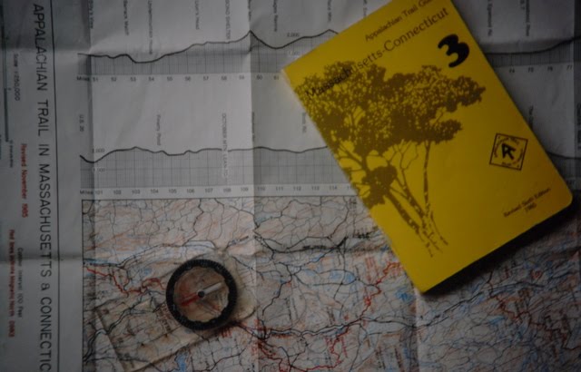
Most of the maps used when I hiked the Appalachian Trail were strips. I often found myself wanting to know what was just off the map. At night, I might look at distant cities lights below and wonder what city, but it was off your map.
The same is true with the old American Automobile Association’s TripTik maps. They were fine for showing you what was on the roads you intended travel. But what if you decided to take a detour? Of course, they also had state maps that provided such detail.
My favorite maps are the old 7.5- and 15-minute quadrangle topographical maps. When hiking out West, I often used such maps. Standing on one peak, I could pick out the other peaks. With such maps and a good view of the terrain, I would orient myself without even pulling out a compass.
The sad future for maps
Sadly, maps are going out of style. We now navigate more and more by GPS and google or Apple maps. The electronic version, seen on a 3 inch screen, makes the old TripTiks seem full of detail. I also find it much harder to dream using an electronic gadget. The linear strips of maps focus us just on where we are at and where we are going. We fail to see ourselves in the world. These medieval maps remind us that world is complex when we add the spiritual realm. I ordered the book. When it arrived, I skipped over other books on my TBR pile to delved into Deam’s medieval world.
Lisa Deam, A World Transformed: Exploring the Spirituality of Medieval Maps
(Eugene, OR: Cascade Books, 2015), 142 pages including notes, drawings and photos.
Lisa Deam has a PhD in art history. Torn between the study of art and religion, she found a way to blend the two with medieval maps. These old maps are not the equivalent of the gas station maps I grew up studying. Such maps were works of art. Most of these maps centered the world by placing Jerusalem, the locale of Christ’s atoning death and resurrection, in the middle. Everything else in the world flowed there, including the three known continents of the pre-enlightened world.
Some of these ancient maps also had Christ behind the world, with his hands and feet holding the world up. Often the edges of the maps contained monsters and were scary places. But with Christ’s hands and feet the medieval travelers were reminded they were not alone when travelling. God’s protection was present.
These maps also contained a lot of information. Of course, some of the monsters were fantastical, but the map contained bits of history beyond what happened in Jerusalem. Interestingly, one of the themes were the conquests of Alexander the Great. Of course, one studying such a map in the 1300s would have no idea or first-hand knowledge of these places where Alexander or even Jesus walked.
The Hereford Map, produced around the year 1300, receives the most attention from Dean. This four-foot map resides in the cathedral has great detail. She also spends time with the Ebstorf Map and a small “Psalter Map.” Unlike the other two, the Psalter map was designed for private devotion.
Recommendation
Dean does not set out to write a history of cartography. Instead, we’re taken into the world of the era and invited to think of how their worldview and beliefs were seen through these maps. In addition, questions at the end of each chapter invites us to contemplate about our own lives and worldview in relation to God. While the book contains much new knowledge of maps in the 13th and 14th Centuries, it’s really written as a devotional guide.
I enjoyed reading this book. I only wish it included a 4-foot square copy of the Hereford Map that I could have spent lots of time poring over as I read the book. It does include a small version of the map and a few large, detailed sections of the map for the reader to see with their own eyes what the author is describing. I recommend this book.
Check out Lisa Deam’s other book, 3000 Miles to Jesus.
We used to have many map books, but these days with technology it’s rather different.
We can still enjoy seeing framed maps on our living room walls though 🙂
All the best Jan
Wow, that book sounds right up my alley! Not only because I love maps too (how could I not, being a Tolkien fan :p ), but because it could also be really helpful for my three books that are set in the 15th Century. The oldest, loveliest map books I have are Muirhead’s Blue Guides for England, Scotland, and Wales, now nearly 100 years old!
Your maps sound interesting. Next time I’m over that way, Hereford will be on my list of places to see. I haven’t yet been to that side of England, so a train through the countryside is in order.
I’ve always loved maps! That sounds like a very interesting book.
Maps bring out the wanderlust in me!
I remember when all the classrooms had maps on the wall that the teacher could pull down. The globe atlas of the world was in all the classrooms and a lot of people had them at home too. You just don’t see things like that anymore.
You’re right, the multiple types of maps that could be pulled down depending on the lesson. It was always interesting to see how the maps had changed–I remember one set of maps were done pre-World War 2, this was in the late 60s. Now I’m sure they use a smartboard or a digital image.
I love map very lately……but, love atlas.
Nice essay… thank you for sharing.
Yes, atlases make up a solid section in my library
Digital maps don’t give the breadth that paper maps do but I guess that’s what we have until VR kicks in.
I think I’m glad I’ll old enough to miss Virtual Reality. I like the sense of adventure in the real world.
One of my favorite possessions is a very old framed map of England with the names and locations of different book settings noted.
In my study at Bluemont, I have an repuduction of an 1875 map of Virginia City, Nevada, which I have framed and spent many hours looking at (especially when writing a dissertation about the area).
My recently deceased father-in-law loved gadgetry, and was an early user of GPS. He never fully trusted it, though, and when he traveled he kept a map alongside it.
I use them both when driving or on the water, but hiking, I tend to only use a map.
There is a book by William Buckley titled “Racing Through Paradise.” It is about a trip in a sailboat across the Pacific in the mid-80s, just as GPS was coming online (but before it was available commercially). Using his connections in government, he was allowed to take an early unit and matched it with his own celestial navigation. I reviewed the book in my sagecoveredhills blog many years ago. It’s a primer on how “snobs” sail (the amount of wine and liquor blew me away).
Cool story, Jeff. Sounds like a good book that you recommended. Most of the love affairs I had as a kid I have outgrown like baseball cards and video games. I wonder if they will return when I have more time on my hands like I did when I was kid.
I wish I had my old baseball cards from the mid-late 60s!
This was a fun post, Jeff! I’ve loved maps since I was a little girl, Jeff. I drew the first real one I remember in grade three, and it was of our fishing village of Margaretsville, Nova Scotia. Of course, my brother and I were already drawing imaginary pirate treasure maps and the like. The 7.5- and 15-minute quadrangle topographical maps are my favorites too. I loved how you could visualize the landscape in 3-D. I never saw them until I went to university and learned how to create cross-sections of topographic and/or geological features. When I worked in petroleum geology, I had several projects where I had to create maps of the top of an oil-bearing formation buried about 5000 feet below the surface in Western Kansas ~ so much fun! I have well over a thousand maps in my collection.
That’s quite a collection. As a geologist, I assumed you’d be into maps!
I enjoyed maps as a kid, sitting in the backseat and examining the state map of wherever we were traveling. I’ve also enjoyed them while researching my genealogy. The cover of the book looks intriguing.
The cover is from the Hereford Maps.
I too am a map lover and dreamer. My spouse has never understood how I can pull a 7.5 minute map out on the table and look at it for hours. I can. One of my woodworking projects is to build a map cabinet for all his 7.5 minute and other maps. I’m hoping perhaps later this year on that one.
Another project of mine since discovery of online canvas printing places is to get maps printed onto canvas, stretch them on a frame and hang them up on my office wall so I can stare at them without ever hunching over a table. To date I have only done one as a trial and it was a success. I really need to start doing more.
I have often thought of getting an Appalachian Trail map framed for my office–one that’s about five feet in length. I like the idea of a map tray.
I love maps, too, so I thoroughly enjoyed this post. I don’t think I’ve ever used a strip map. I still have a few old road maps stashed away somewhere (I was always good at folding them back up), but my favorites to pore over are my world atlas and my big road atlas. (both out of date, I’m sure)
Karen, the Hereford Map would make a great puzzle! I wonder if they have such available at the cathedral? I wouldn’t mind having a life-size copy of it in my office.