

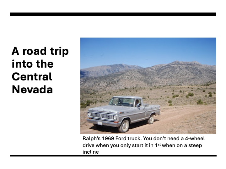
Last Thursday, February 12th, Lincoln’s birthday, was also the 100th birthday of a late friend of mine, Ralph Behrens. That evening, his son (Rob who lives in Northern Utah) and I each had a Scotch in memory of his dad.
Ralph and I met at a potluck dinner for Boy Scouts Troop 360. It was late 1993 or early 1994,, shortly after I moved to Cedar City, Utah. Sometime that evening we started talking. Ralph learned of my interest in mining towns as I had written a few journal articles on the Comstock Lode. At the time, I was considering returning to school for another degree. My hope was to write a dissertation focusing on the role the church played in mining camps.
I learned that Ralph grew up in Goler Gulch, a mining community in the Mojave Desert of California. It was a rough place to live during the Depression. Ralph graduated from high school in 1944 and joined the Army Air Corp. He arrived in the South Pacific near the end of the war, but earn a combat ribbon because, as he was fond of say, “some General wanted another metal so they loaded up a bunch of bombs on a 100 airplanes and we flew and blew the hell out of a handful of Japanese on an island we didn’t deem important enough to invade.”
Shortly after that potluck dinner, Ralph and I started taking regular trips out into the desert. I’m not sure exactly how many trips we made, but we did at least a dozen or so trips in Utah, Nevada, California, and along the Arizona Strip. I even helped Ralph cut and haul wood for several years to heat his house. One trip we didn’t get to make when I was in Utah, but had discussed, was to the Hole in a Wall. In 2006, a couple years after having left Utah, I flew back and the two of us set out to visit this spot. While not an overnight trip, this was the last big trip we took. The next few times I visited, Ralph’s health had declined to the point he could no longer able to travel in such a manner. Ralph died in 2010.

The story below I wrote in 2006. I’ve edited it and republished it here.
We arrive in Escalante around 11 AM. This must be one of the strangest towns in Utah. A few years ago, the Mormon influence remained so strong you had a hard time finding 3.2 beer. Interestingly the town isn’t named after a saint, but a Catholic priest. Father Escalante came through here a century before the Mormons settled this area. He searched of a faster way from Santa Fe to the California missions. At that time only a few small bands of Paiutes lived in this hostile environment, descendants of the Anasazi whose culture flourished here until abruptly disappearing around 700 years ago. As Escalante discovered, travel in canyon country is difficult. It’s easier today, but by modern standards is still difficult.
I hadn’t been in Escalante for five or six years. The town appears prosperous; almost negating the doom predictions of the naysayers who predicted President Clinton’s creation of the Grand Staircase National Monument would be a catastrophic event. The town now has sidewalks with classic streetlamps, several new businesses and a new high school. Ralph pulls up in front of the Golden Loop, a diner. The logo has a cowboy standing tall in the saddle, with the “golden loop” of his lasso falling over the neck of a calf. As it’s not quite time for lunch, we hit the Roan Pony Bookstore next door first. I know right away things have changed in Escalante.
“Don’t sell too many books to locals, do you?” I quip sarcastically to the salesclerk.
“We sell a few children books,” she replies, “but not many to adults.”
“I bet not,” I say while reading through the titles of books critical of the Mormon faith. She has a couple copies of Fran Brodie’s, No Man Knows My History. It’s a good biography of Joseph Smith, the faith’s founding prophet, and written by a granddaughter of Brigham Young, the faith’s second prophet. It’s been over fifty years since this book came out. Its publication got Brodie excommunicated and the book placed on the church’s blacklist. There are other books critical of the Mormon Church including a few titles by people who have left the church, encouraging others to follow in their footsteps. In another section of the small store are the works by Michael Moore, Calvin Tillian, Al Franklen, and other liberal thinkers. Not only is this Mormon country, but this is also Republican country, and these titles won’t gain her any friends.
The Roan Pony also features a section reserved for environmental writers, Abbey and McPee and a host of others. The only thing worse than a liberal in this country is an environmentalist. Pick-up trucks all sport bumper stickers critical of environmentalists and nature lovers. “Hungry: Eat an Environmentalist,” reads one. Not too far from here, over on US 89, more than one effigy of Robert Redford has dangled in a noose. It’s obvious the Roan Pony isn’t marketing itself to the locals, but there are now plenty of tourists now flocking in to see this rugged country. I admire the owner. She’s a brave soul. Just having this bookstore in Escalante is akin to Jeremiah of the Old Testament standing up and telling King Zedekiah and his court what they didn’t want to hear. Of course, Jeremiah got thrown into a well.
The Roan Pony advertises a 20% off sale. She’s preparing to close for winter in a few weeks. I pick up a book that’s been on my reading list, Paul Theroux Dark Star Safari, figuring with a 20% markdown, I can support the local economy.
After the bookstore, we enter the restaurant and sit at a table. It takes a few minutes for the waitress to get to us. I order a hamburger and iced tea. Ralph asks for chili and coffee. After a few minutes more she brings out drinks. Then the waiting really starts. After a good fifteen minutes, after I’ve finished my tea and he’s drunk his coffee, Ralph quips: “If they keep up at this pace, we can make it dinner.” Not very happy at the service, I nod in agreement, saying something about them having to catch a cow before they can butcher it. But then the meal comes and the burger is tasty. This isn’t any corn fattened cow, its range fed and you can taste the difference.
As we’re finishing up with lunch, Ralph tells me the problem he’s been having with the lights on the truck. He can’t remember if he got ‘em fixed. I’m sure there was a speck of horror on my face. Ralph doesn’t use this truck much anymore, but he’s always keeps it in good running order. Seeing that we’ve lost an hour between the bookstore and diner, and there is little chance we’ll get back before dark, I heartily agree that we should check the lights out before we leave town. They work!
Ralph then tosses me the key and asks me to drive, complaining of his shoulder. As I maneuver out into the street, I ask if we should top off the tank. He doesn’t think so since the truck has a full 18 gallons reserve tank. We have plenty of snacks and water, just in case. We leave the town and civilization behind.
Just out of Escalante, we take the graveled “Hole in a Rock Road,” which runs southeast. Its fifty-four miles from the point we leave the pavement until the trail dead-ends on an overlook at the Colorado River. In the 19th Century, Mormons used this road to migrate into the Arizona Territory. It was a long and punishing trip. Once they got to the “Hole in a Rock,” an opening in the mountains above the Colorado, they lowered their wagons with ropes down to the ford in the river. The ford is gone; the Glen Canyon dam has flooded this part of the river to create Lake Powell.
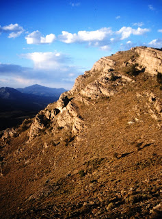
Imposing cliffs rise to the right of the road, with bands like chevrons of different colored sediment running nearly the fifty miles. To the left, the country drops off into canyons that lead down into the Escalante River. There are a few signs noting points of interest along the way. There are also a handful of mileage signs which aren’t consistent. After ten miles on the road, a sign says its 51 miles to the end. Then, after only a mile, another sign says its 42 miles, which is about what we expect. Yet just a few miles beyond that sign, another one says we got 46 more miles.
“You driving backwards, Ralph asks? We don’t place any confidence into the signs.

The first thirty miles of the road is good; or as good as gravel roads in this country get. This is high desert; as far as one can see there are pinion and juniper trees, yellow rabbit brush, and sage. Just off the road, to the west, are acres of unique rock formations known as the Devil’s Garden. Large beige columns of mushroom like sandstone cover the area.
Afterwards, the road continues to lose elevation, and fewer trees are seen until somewhere under 4500 feet, they become non-existent. However, there are flowers: Orange Mellow, Sego Lilies, Snakeweed. It’s a pleasant surprise to find so many flowers blooming this late in the season, but the area has recently had rain as evident by the muddy bottoms in the ravines. Yucca plants are also prevalent, their spring blooms long dried by the sun and wind. Cottonwoods grow in a few washes, an indication of water in this barren land.

As we approach the end, the cliffs and the canyons draw closer and the road snakes down into washes, only to wind steeply out of them. Driving is a challenge. The truck has no power steering, and I fight with the wheel while constantly downshifts to keep from burning out the brakes. On a few occasions, I even double clutch the truck into low, to get enough power to climb a steep embankment. We’re swung around at every bend. Driving, I recall the chase seen across slickrock in Edward Abbey’s Monkey Wrench Gang. But we’re not being chased by the Sheriff out of Moab, so I slow down.
It’s getting late in the afternoon, and we both begin to worry about getting back to the pavement before nightfall. Around 4 PM, after having covered maybe 2 miles in the past thirty minutes, we give up. We’re at least 4 miles from the “hole.” I was willing to continue, but I’d been there about 10 years earlier. Ralph had never been out this far. After swearing that it’s the worst road he’s ever been on (and he grew up in the desert Southwest), Ralph suggests we turn around.

Coming out goes faster than going in even though we’re driving into a north wind blowing sand down the road. Whenever we stop and get out, the sand stings my bear legs. As the sun drops closer to the Kaiparowits Plateau, we have one final adventure. I tell Ralph we’re low on fuel in the main tank and he instructs me on how to change tanks. I do and a minute or so later, the truck runs out of fuel. We stop to check things out. The switch has broken.
“What are we to do now,” I ask?
“Don’t worry,” Ralph says. “I’ve got my Oklahoma Gas Card,” as he pulls out a flexible tube from behind the seat. Although a toddler when his family left Kansas for the desert, Ralph somehow retained a prejudice against the southern neighbors of his infancy.

For the time being, I switched back over to the main tank and drove cautiously. The needle pegged empty as the sun slips below the mountains. I let out a sigh of relief when we turned back onto the blacktop of Utah Highway 12. A few minutes later, we’re back in Escalante and I pull in under the lights at a gas station. Filling up the main tank, I calculate we had less than half a gallon left in the tank. Had we continued on to the hole in a rock, we’d been out of gas and siphoning it from the other tank before we got back to civilization.
Once back on the highway, I watch the stars appear as we head west, arriving back at Ralph’s home in time for a late but wonderful dinner of short ribs, prepared by Pat, Ralph’s wife. Ralph fixes himself a martini and offers me a Scotch.

Other stories of traveling with Ralph
Camp Bangladesh (A humorous look at the two of us as summer camp Scoutmasters)
Goler Gulch (where Ralph grew up)
A 94 year old red head and the mother of Ralph’s childhood friend
