
Tuesday afternoon and evening, June 24, 2025

Rounding Raynolds Point, the northeastern corner of the island, the situation changed. I was no longer on the lee side of the island. The wind was in my face and much stronger. Swells suddenly appeared, breaking over my bow and attempting to push me onto the rocky ledges around the shore. Dark clouds gathered. I headed out away from the ledges and paddled harder. Having already covered approximately 19 miles, I was tired. As rain pelted me, I decided to head into Raynolds Bay. The wind helped this decision. I was not sure what’s public and private land, but there were no signs of human activity. The bay provided enough protection for me to safely come ashore. After thirty minutes of excitement, I was exhausted. This was the first bit of difficulty on my trip, but it would not be the last.

I walked along the cobblestoned beach that’s sprinkled with fossils. There is also evidence of beaver activity, but wonder what they might attempt to dam up here. A dam on these waters would be beyond the Army Corp of Engineers ability. Finding a nice place where I could pitch my hammock and with a good view of the shore, I move my kayak.

Again, as the previous night, I found a rock out near the water where I set up my kitchen. After dinner, I gathered wood for a fire along the beach. The skies cleared. As the daylight fades, I read and write by the water. Then I build a fire and fix a pot of tea. I hope to see the northern lights., but don’t see them. As darkness falls, I see distant lights of navigation markers and Canadian radio towers. I also pick out cabins by their lanterns on islands on the Canadian side of the water. Twilight seemed to last forever. I crawled in my hammock at 11 PM, after making sure the fire was extinguished. The stars had just begun to appear.

Monday, June 23, 2025
My trip started on the previous morning. I take the 7:50 AM ferry from Detour Village to Drummond Island. Arriving at the Fort Drummond Marina at 8:15 AM, shortly after they opened, I unloaded my boat from the top of the car and stowed my gear into the hatches. While I plan for a three-night, four-day trip, I bring extra food in case the weather deteriorates. After loading my boat and moving my car to where it’ll be out of the way. I then leave a float plan with the operator.

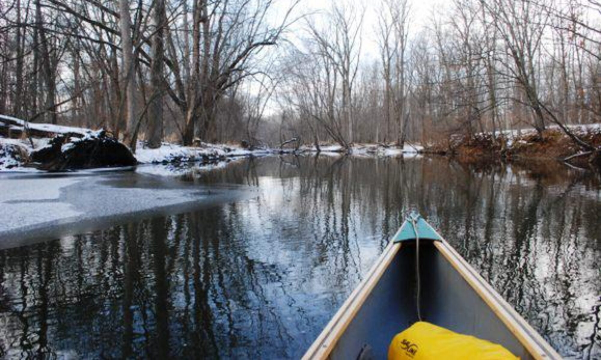
I’m on the water at 9 AM, paddling south out of the tributary where the marina is located. At first I paddle rather slowly as I finish my thermos mug of coffee. Then paddle much faster as I reach Whitney Bay and set my course between Bird and Garden Island. Once I clear Garden, I’m in the upper ends of Lake Huron. From here, I can watch freighters coming up from the south. I turn east and round Anderson Point, then aim between Bootjack and Espanore Island. Next, I head southeast toward Cream City Point. At 11 AM, I pull up on the backside of Gravel Island in Huron Bay for a rest and lunch. I’ve covered 8 miles in two hours of paddling.
Today’s lunch is fancy. I have a left-over steak over from Saturday night dinner. Placing the steak inside a hoagie bun, I eat it while watching another freighter make its way from below the horizon towards the Soo. I then take care of a few messages I received on my phone. One is from my brother and I snap and send him a photo of my kayak resting on the cobblestones. Another is from Dave, a friend on Drummond, who invites me to dinner at a friend’s place on the third night. He asks if I can make it. I think I can. This will be the last reliable cell service until I have paddled around most of the island. For the rest of the day, I leave my phone on airplane mode to save battery.

After lunch, I paddle around the north side of Gravel Island, and set my course for the distant Traverse Point, 2 ½ miles away. My course takes me further from land. Having paddled by several points, I realize I must give these points wide berth to avoid the rocks which often sit at or just below surface.
After Traverse Point, I head due east toward Scammon Point. This route takes me far from the shore as I pass Canoe Point and Scammon Cover. There are also fewer cabins along this isolated part of the shore. Most of this land is managed as a Michigan State Forest. Leaving Scammon Point, I am tempted to head into Big Shoal Cove, where there is a sandy beach. Having been there before, several years ago, I decide against it. I head southeast toward Long Point, the third of four points I can see (the last is an island).
I arrived at Long Point around 4 PM and paddle around both sides of the point. After looking around, I decided to camp on the west side, a 100 or so yards inside a small bay. The beaches were covered with cobble stones. As I had done at lunch, I paddled close to the water’s edge and get out of the boat while it’s still in about a foot of water. I lift the boat up, to avoid most of the rocks. After unloading and my boat was lighter, I carry the boat up onto dry land.
Before setting up camp, I take a brief swim. The water in the shallow bay was cool, but not cold. Then I put on long pants, socks, a clean long sleeve shirt.
I find two cedar trees at the edge of the woods, where I hang my hammock. Around it, I felt I am in a garden with purple irises, buttercups, Indian paintbrush, and other flowers. On a large rock about 75 feet away, I place my stove and pot along with my folding chair. After everything is up, I update my journal before preparing dinner. This consists of a beef stew which just had to be heated along with two tortillas and some apple sauce in a squeeze container. Paddling allows for heavier food than backpacking.
After dinner, I hang my food between two trees and explore the shoreline. Afterwards, I fixed a cup of tea. Sitting down, I sip my tea as I watch the sun set and a thunderstorm build south of me. For the next half hour, I observe the storms moving east, just south of me. Huge lightning bolts strike the water a mile or two to my south. These are followed with delayed rolls of thunder. As darkness falls I am treated with a display of synchronous fireflies. Each of these bugs, along the woods, emits four or five quick blinks of light. This is followed by 10 seconds or so of darkness before another set of blinks. To the west, I caught glimpses of the new moon hang between the clouds, low in the west.

I fell asleep to the waning sound of thunder. About 3 AM, I wake and crawled out from my hammock to take care of business. The skies have cleared and to the south I see the pincher stars of Scorpio above the horizon. Moments later, I snuggle back in my hammock home and fall back asleep.
Tuesday, June 24, Morning to Midafternoon

When I wake again, a mosquito buzzes just outside my netting. The sun rays are lighting the trees on the other side of the bay. I get up and fixed breakfast. This consists of oatmeal and perked coffee. Then I packed up everything, and spend some time reading and writing in my journal.
By 9 AM, I am again on the water. I paddle east, crossing to the outside of Shelter Island and the points on each side of Bass Cove. Afterwards, I turn northeast as I reached the eastern side of the island. Unlike the day before, where the island consisted of many points of land the eastern side is smoother. There are only a few jagged points extending into the water. Around Bass Cove, I pass many cabins, As I paddle north, I see fewer cabins. Most of this land is owned by the state. With Drummond Island just a hundred yards to my left, Canada is less than a mile to my right.
Unlike the day before in which, after leaving Whitney Bay, I saw no boats (except for distant freighters), I passed a large sailboat heading east. The boats sails are furled, and it motored on. I later see a few boats come down through the False Detour Passage that links the Northern Passage to Lake Huron.

I planned to make my first stop at Marble Head, a rough outcrop of limestone at the eastern most point of Drummond Island. Who knows why they named this place Marblehead. Drummond, as far as I know, has no marble. It is mostly limestone and the mine on the island produces shiploads of limestone every week, which is used in steelmaking, cement, and agriculture. I suppose the name had a nautical sound. I crossed by Marblehead and pulled ashore on the north side. Stepping out of the boat, the biting flies started. I grabbed snacks for lunch and bug spray. I sprayed my bear legs, where the flies seemed drawn (I wore a long sleeve sun shirt which seemed to provide some protection from the flies. But the spray didn’t deter these buggers, and I spent lunch swatting them away.
I had planned to hike up to Marblehead, but the bugs seemed just as nasty inside the forested canopy, so I returned to my boat and slowly continued to work my way north toward Stigraves Bay. I’d also planned to paddle into Pilot Harbor, which has a narrow entry that opens into an inland lake, but decided against it. I paddled north around Glen Point and into Glen Cove. It was only 1:30 PM.

Most people who paddle around Drummond Island spend their second night at Glen Cove, but since it was too early to stop, I decided to continue north. In the distance, I see a rock that looks like a giant bald eagle sitting. Getting closer I see the white part is from bird poop. But, as I pass this rock, I do see a bald eagle soaring above.
The weather was delightful with a breeze out of the northwest, keeping me cool when I stayed offshore. When I came in close, to explore the limestone ledges which began appearing north of Marblehead, the shore blocked the wind and the bugs would attack. I assumed once I crossed Raynolds Point, 6 or 7 miles ahead, the wind would blow the bugs away.
My decision to continue also was influence by the invitation to have dinner with Dave, Sandy, and their friends on Wednesday night. Except for the bugs, I find the northeast side of Drummond delightful. Much of the shoreline consisted of flat ledges, table-like limestone, a few feet above the waterline. The “tables” appeared properly set with wildflowers growing in cracks. In most places, a second ledge extended out six or 12 inches below the water line.
Getting ashore isn’t difficult, as I exit the boat in six inches of water and climb upon the ledge. It would have been more difficult to have camped along the shoreline north of Glenn Cove, as one would have to load and pack the boat in the water and then lift the boat up onto the higher shelf to keep it safe at night. I decided to camp west of Raynolds Bay. Furthermore, most of this land is privately owned. However, only a few cabins dot the shoreline.
To continue, click here.

I’m glad you included the map to give us a better idea of your trip. The fossils are neat! I know you take all the right precautions and I’m sure someone knows where you are the whole time, but I’m always a bit wary of solo adventures.
It’s always NOT recommended, but there is something about being alone in the wilds. While most places I couldn’t use my phone, I also carried a marine radio and a 2 meter Ham Band radio, so I had ways to communicate if I needed. And on my phone, I can always send an SOS text out via satellite.
We were in Michigan last week and went up to see the Soo Locks. Lots of big ships going through. Quite fascinating! This time of the year is so beautiful up there. Your trip sounds great. Can’t wait to hear the rest.
Hey Cuz, I will have at least two more posts about the UP. We just missed each other up there. I’m wondering, did you drove up from the Wisconsin side of across the bridge in Michigan?
You are doing what my more adventurous self would do. Thanks for taking me along. 8 miles in two hours of paddling–does that sound like a lot? I won’t even ponder the strength in your arms. Phone running out of battery? I am paranoid of that, always carry two backup batteries for long trips.
I take a larger battery pack which I charge my battery with at night, but when your phone is always searching for signals, it runs down the battery fast. I used the phone for photos, so I just put it on airplane mode. When I next got signal, some of them were from Canada.
Good point. I made that mistake early on, before I knew better, on a cross country flight.
Thanks for the vicarious adventure. I love the images–fossils–not you :-), beautiful sunsets, and isolated vistas. There’s nothing about this I don’t love.
Thanks for clarifying which fossils 🙂
An area I’ve always wanted to visit. And now I have. Thanks.
The UP is an amazing place
Sounds like you had a good time. Loved the pictures.
I enjoyed the trip.
Looks like a wonderful adventure, Jeff. Thanks for sharing.
I had a great time!
As I normally do when reading travelogues, I google up a map and follow along as I read. I was surprised to see you included a map at the end of this entry.
Unfortunately my satellite view doesn’t do it full justice as Raynolds Bay looks just like Glen Cove Bay only with a much wider beach. I can’t see the shelf of rock in Glen Cove.
The shelf ledges star north of Glen Cove. All of Drummond is limestone and in many places there is Alvar formations which creates flat, almost like cement, rock surfaces which also creates a unique environment for plant life as the soil thickness is thin or in some cases none, requiring plants to grow in the cracks.
The map I included at the end isn’t the best. The one I featured in the photo at the beginning that’s all wrinkled and torn is the one I used while paddling. It’s a lot better with more of the features highlighted.